THINGS TO SEE & DO


🌊 Tidal Wonders Await
Experience the World's Highest Tides
Bay of Fundy
The Bay of Fundy is home to the world's highest tides, with a record tidal range of 16.8 metres (54.6 feet) in the Minas Basin, Nova Scotia.
Tides here rise and fall twice daily, driven by the gravitational pull of the moon and the unique funnel shape of the Bay. This “sloshing effect” amplifies the tides to world-record heights, with up to 115 billion tonnes of water moving in and out each day — enough to fill the Grand Canyon twice!
The mighty Fundy tides create a gradual but powerful transformation, exposing vast mudflats at low tide and completely flooding them hours later. Ships float at their docks at high tide and are left high and dry when the waters retreat.
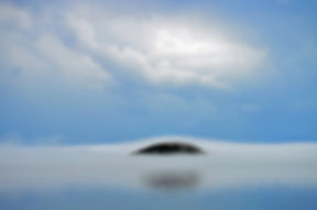
Spencer’s Island and Advocate Harbour are perfect spots to experience this incredible natural wonder firsthand — along with beaches, hiking trails, and stunning sunsets over the Bay.
🧭 Places to Explore
🏠 Cape d'Or Lighthouse
Breathtaking ocean views, rare falcons, and rich maritime history.
🥾 Cape Chignecto Provincial Park
Hike towering cliffs and secluded beaches — nature’s masterpiece. Cape Chignecto offers a 52 km (32 mi) coastal loop
🌊 Spencer’s Island Beach & Lighthouse
Historic shipbuilding, beachcombing, and the charming lighthouse museum.
🪨 The Three Sisters
Stunning sea stacks sculpted by the mighty Fundy tides.
🛶 Adventure & History
🧭 Local Guy Adventures
Outdoor tours to hidden gems and wild places.
⚓ Age of Sail Museum
Step back into the golden age of shipbuilding.
🛶 Nova Shores Kayak Tours
Paddle close to cliffs, caves, and secret beaches.
🦖 Joggins Fossil Cliffs
Walk through 300-million-year-old fossil sites — a UNESCO World Heritage Site.
Enjoy high-quality theatre, music, and events celebrating the Atlantic region’s culture.